|
Part 2: The Trek South
Day 21 and 22, (4390) 54 miles to Lincoln, ME
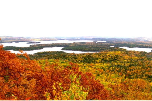
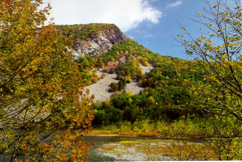
Spectacular View from Almanac Mountain
We arrived at Pete and Mary Lucas's home around noon time. Pete is an old chum of mine from my boyhood days in Hampden. After a great lunch they took us to Almanac Mountain where we hiked to the edge of a steep embankment which looked out over a valley covered with fall foliage, several lakes and, all in all, a spectacular view.
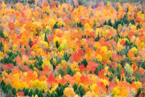
A Collage of Color below Almanac Mountain
The next day Mary went to work while Pete, Maren, and I went up to Baxter State Park just above
Millinocket, Maine. Mount Katahdin is its most outstanding feature and though the map says it is only 5267 feet tall, Pete and I know for a fact that it's a full mile high for we have seen and even contributed to the 13 foot high pile of rocks on its peek that makes it so. In our youth (several hundred pounds ago) we both tracked over most of the mountain and the lakes and streams surrounding it. Today we took a short excursion from Roaring Brook Campground to Sandy Stream Pond.
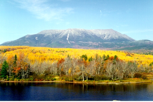
Mount Katahdin, the start of the Appalachian Trail
The foliage was a bit past its prime with mostly yellows and greens against the slide scarred face of Mount Katahdin. We
climbed out onto a large rock which extended into the lake and took it all in: the mountain reflecting of the lake, the breeze whispering through the trees, and the love sick cry of that cow moose about 250 feet to our left. A bull with a huge rack answered with a few grunts and gave chase. Playing hard to get the cow waded out into the lake with that bull hot on her heels while I reached for that new 300 mm lens for my camera. We watched for about 15 minutes as she bellowed and cried while the bull countered her every move. Hoping to get some closer pictures we went back to the trail to circled around to where the amorous duo had entered the water.
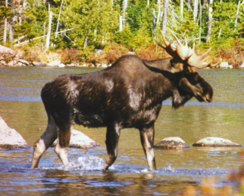
A Bull Moose on the Prowl
We ran along the trail, turned in at the supposed spot, and raced for the water. And there they were, half a dozen other photographers all snapping pictures like crazy. The cow and her admirer stood their ground as more and more shudder bugs showed up and started taking pictures.
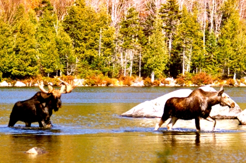
In Hot Pursuit
Well, all this unexpected attention wasn't exactly what the cow had in mind so she left the water with the bull following closely behind. They both nonchalantly grazed on shrubs along the shore as the photographers closed in. When they had everybody where they wanted them the cow and bull broke for the deep woods. The photographers, knowing when they were licked, stood around talking about lenses, film, and f-stops while hoping the pair of moose would return.
"What do you suppose they're doing now," asked the photographer with the huge 600 mm, F4 lens.
"Well, if I read the signs right," I said with my best Maine drawl, "I suppose he's sittin' back smokin' a cigarette by now."
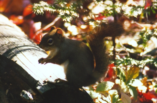
Heading back we saw this chipmunk keeping a wary eye on us
Day 23, (4491) 101 miles to Bar Harbor, Maine
Bar Harbor is a ritzy little seaport on Mount Desert Island along the coast of Maine. It's full of quaint shops, lovely restaurants, and all of the other attractions designed to separate you from your money. Being the last day of the season, Maren kept busy darting from one half-off sale to another as I trudged along behind her carrying the bags. Though that bull moose would probably deny it, it's amazing how much alike our two species are.
Day 24, (4663) 172 miles to Saco, Maine about 18 miles south of Portland
Yesterday and today we move in and out of the "Zone," the zone of peek fall foliage that is. Some areas were predominately bare branches with a few remaining yellows while others blazed with reds, oranges, and yellows. We headed down-east today. For you non Mainerds (not Maineacs or even maniacs) that means we went to the southeastern coast of Maine although it is generally south and west of almost every place in Maine.
There is a certain minimum vocabulary one needs to learn to successfully travel through Maine. Words like aaya and wicked are used profusely; as in "Aaya, she makes a wicked good cup of coffee." Then there is the dialect. Think of it as a drawl with a dusty sense of humor. There is no describing it; you simply have to experience it. But not to worry, most people, when they recognize you as an outsider, will lay it on thick just long enough to see your anguish, then they will switch to English.
On our way down-east we stopped for a spell in Thomaston at the state prison store. They had a lot of nice woodwork and knickknacks. After lunch we went to Freeport. Boy has it changed! The whole town is a mini-mall, no, on second thought it's a maxi-mall. They have one of those stylized maps with 177 entries to help you get around. We went through several of the L. L. Bean stores without succumbing to any temptations. Then while Maren went to some of the other stores I went down to
the DeLorme Map Store to look at their latest CD ROM and GPS combination. It's a street map of the US with a Global Positioning System to tell your laptop where you are within a car length or two. You can plot a route and then have it talk you to your destination; all for $150.
Day 25, 26, (4772) 109 miles to Pepperell, Massachusetts
On the way down from Maine we stopped at our old house in Chelmsford. It looks good and we managed to see our next door neighbor Jane Doyle. We spent two days at my brother Tim's house with the family. Saturday we all went to a German October Fest and saw a lot of the area. It was a bright, sunny day with crisp fall air and the foliage was just a little past prime. It was good seeing everybody again and we had a great time.
Day 27, 28, (4854) 82 miles to Brockton, Mass. Sunday & Monday, October 19th & 20th
Sunday we drove down Route 2 through Concord, past our old house in Arlington and into Boston. The Charles river was full of sculls. They were having a regatta and the banks were lined with spectators. Luckily we went down Storrow drive and not Memorial drive, on the north bank of the Charles, where the spectators were packed in tighter than a sports bar during the World Series. Rounding a corner, watching the race and the road at the same time, I came upon the first low bridge. Ten foot clearance the sign said as I slowed to a crawl remembering all those stories of trucks and busses getting stuck under them. With a great deal of apprehension I eased the
motor home under it. I had measured the clearance at home and knew that it should fit with an inch or two to spare and luckily it did. Well now I know!
We saw a bad accident just before we reached downtown Boston. There was a pigeon and a hawk lying side by side along the road. I can imagine that pigeon ripping through the air with the hawk right on its tail feathers when they slammed into the side of a car. Awe yes, city life; it can be very hazardous to your life.
After half an hour struggling to find a parking space we visited Jim and Marilyn
Cannon at the New England Medical Center in the heart of downtown Boston. We were going to stop by their home in Randolph but
Marilyn was admitted with a bowel obstruction last week so we met with them in the hospital. She hopes to be going home Monday and everything is expected to be fine.
Later we stopped by to see the LaBells and catch up on the past 25 years. That evening we went out to dinner with the Mannings and will be spending two nights with them just across the street from our old house on East Ashland Street. The house looks good although the garage has been converted into a room, but otherwise it looks the same from the outside.
Day 29, (5089) 235 miles to The Bay Ridge section of Brooklyn, NY at the tip of Long Island.
Today we reached the half way mark as far as mileage is concerned. The trip down from Brockton had some colorful spots that were definitely back in the "Zone," but much of the trip was in the strip city along Interstate 95.
We are visiting with Henry and Vivian Deeb, friends of ours we met in Switzerland. Their home is one block from the Upper New York Bay just upstream from the Verrazano Narrows Bridge. It's a pleasant, well-kept neighborhood with a mix of single family homes, du- to four-plexes, and small apartment buildings running from 4 to 7 stories. The whole area looks quaint with well-maintained homes, lots of trees, and small flower gardens in many front yards. About half the homes are decorated for Halloween as are many businesses.
Day 30, (5211) 122 miles to Stokes State Park, NJ just of State Route 206.
At this point Maren is taking a detour to Germany while I will continue
down the east coast. She will rejoin me in Florida in 15 days.
After delivering Maren to JFK at 3:15 P.M. I headed northwest for the Delaware Water Gap National Recreation Area in northwest New Jersey along the Pennsylvania border. The Appalachian Mountain Trail runs through the park not far from where I am camping and I plan to visit a short section of it in the morning.
Day 31, (5367) 156 miles to Denver, PA near the Pennsylvania Turnpike and State Route 222
Delaware Water Gap
After driving through the Delaware Water Gap National Recreation Area I stopped to take some pictures of the Gap where the Delaware River cuts through the Kittatinny range of the Appalachian Mountains. The fall colors are not as vivid here as they were in other areas. According to a park ranger it was a bad year. "The colors started to turn," she said, "then stopped and started to drop." It's a nice area but quite tame. Its major use is canoe, kayak and rafting trips down the Delaware River.
Day 32, (5477) 110 miles to Gettysburg, PA
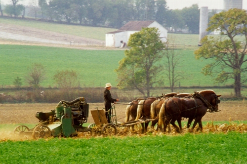
Winding my way through the back roads of Lancaster County, I found the Amish or Pennsylvania Dutch who aren't Dutch at all but Deutsche, as the German's call themselves. There were lots of horse drawn carriages and wagons, but I also have shots of farmers harvesting their fields with teams of four horses drawing various farm machines. I even found a covered bridge and a new concrete one where a covered bridge was marked on the map. I arrived with the rain at Gettysburg where 60 score and 14 years ago Lincoln made his most famous speech.
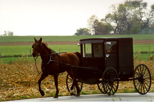
Amish Country, home of the Pennsylvania Dutch
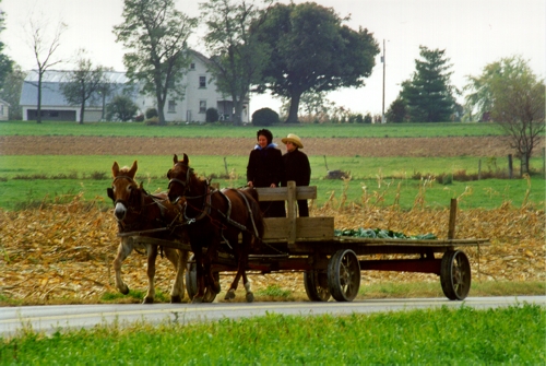
Lancaster County Pennsylvania
A beautiful matched team of four horses
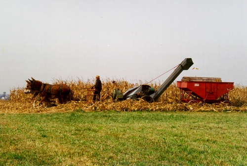
Harvesting Corn
A Covered Bridge with Decoys set out to Catch the Tourists
Day 33, (5538) 41 miles to Harpers Ferry, WV on Route 340 Saturday, October 25th
The museum at Gettysburg occupied my morning. Then came four states: Pennsylvania, Delaware, Virginia, and West Virginia all in 41 miles. I traveled from the sight of the worst defeat for the south to their greatest victory at Harpers Ferry. Enough history, time to get back to the scenery.
Day 34, (5614) 76 miles to Mathews Arm Campground in the Shenandoah National Park
It's a rainy, foggy day on Skyline Drive in the Shenandoah National Park. The Appalachian Trail runs through the park along the same 105 mile route as Skyline Drive, crossing it frequently like a snake wrapped around a crooked staff. I stopped early to let the weather clear so I can enjoy some of the loveliest scenery in Virginia. Locally the fall foliage is about 50% now and should improve over the next several days. I hope to get back into the "zone" again soon.
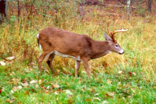
Head of the Herd
Entering the campground I had to wait for a doe and two yearlings to cross the road. Later a mixed herd of six does and youngsters were grazing next to the ranger station, then a little bit down the road two more looked up from the woods. Returning to my campsite, I spotted a nice six point buck in campsite A27. The light was low but I managed to get off a couple of shots, with my camera that is.
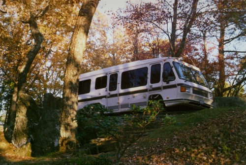
Our Aero Cruiser motor home at Mathews Arm Campground in the
Shenandoah National Park along Skyline Drive in West Virginia.
Day 35, (5773) 159 miles to Otter Creek Campground at mile 60 on the Blue Ridge Parkway, VA
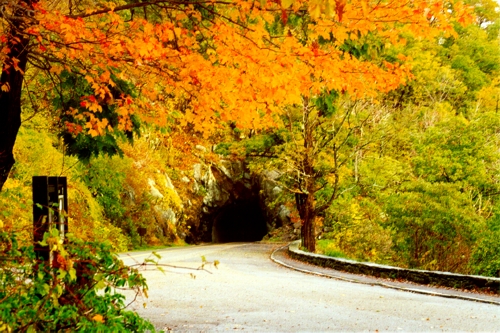
Tunnel toward the end of Skyline Drive
Today marks our half way point in time, five weeks past and five to come. It started with a turkey parade as I left the campground and ended with a bang. About six birds crossed in front of me but by the time I got my camera out they were in the woods and it was too dark to take a picture. The morning was cloudy but it started to clear around 11:00. The colors improved somewhat during the day but are not at their peek, although there was a lot of wonderful scenery.
I took a break during the day, stocked the larder, and had the motor home serviced -- lub., oil, and filter. That afternoon I saw a muskrat beside the road and at dust two deer stood poised to dart across the road, then a few minutes later two more. Arriving at the campsite after dark I studied the parking strip. It was asphalt with a low stone retaining wall around it. The wall was no problem as it was low enough for the body to pass over. I laid the flashlight down where I wanted to stop, pointed it forward to mark a guide path and backed in. Bang! I jumped out and looked around; nothing. I looked under the
motor home and there lay the drain pipe for the waist water, valves and all. It was snapped clean off the holding tank. I had overlooked how low it hung when I sized up the wall. "Oh darn," I said, "Isn't that a shame." (Not an exact quote.)
Day 36, (5852) 79 miles to Natural Bridge Campground 2 miles off State Route 130
The damage wasn't as bad as I thought the night before. The three-inch black-water waste-valve was snapped off on the outlet side and the gray-water valve was intact though hanging free. Both valves still worked and are not leaking. With two shock-cords I managed to tie everything together and took off for the valley floor to get it fixed and see one of the seven natural wonders of the world.
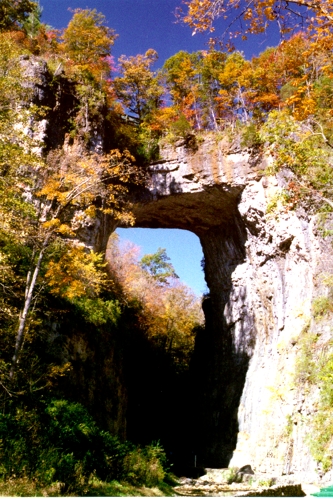 The Natural Bridge lived up to its name.
The sheer cliffs on either side hold a thick yet strangely symmetrical cap. It's not an arch; rather, it is like a mantel on two stanchions. I took some pictures and then went looking for an RV repair shop. I found two. The general opinion was that the whole thing had to be rebuilt but they didn't have all the parts needed. I decided to repair it myself.
The shock cords had worked well and held everything in place even though I had driven over some rough and windy roads. I bought some epoxy, a replacement end cap, and filled up the
motor home with some 99 cent gas! Arriving at a nearby campsite at 3:00 P.M. I went to work before it got dark and colder. The manager probably thought I was crazy when I drove into the camp site instead of backing in but this had the advantage of raising the rear end higher of the ground when I leveled it. Our little propane barbecue made a nice space heater to warm the pipes so the epoxy would cure and I used shock cords to hold everything together while it set. Tomorrow I will drive with my fingers crossed, hoping everything will hold together.
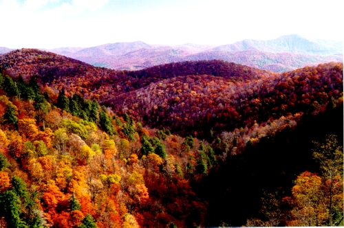
Day 37, (6047) 197 miles to Doughton Park Campground in NC on the Blue Ridge Parkway
This morning several locals told me that the foliage is dull this year because it was such a dry summer. Heading south it has improved considerably; maybe they had more rain down here. This afternoon a local Park Ranger told me that the red leaves have just started to come out in the last day or two and we are three or four days from peek. That sound's about right. When looking across the valley at a nearby mountain, it will be green at the base and in prime foliage on top. I'll just take it slow for the next day or two and try and stay in the zone.
I took a short walk on the Appalachian Trail and ran into a gal maintaining the trail. She brought me to an overlook and showed me the Natural Bridge on the other side of a distant ridge. I took a picture with my new 300 mm lens and then tried it with the doubler on. Without a tripod I don't think the second one will be vary good.
Southern VA and NC have rhododendron and laurel growing wild beside the Blue Ridge Parkway. It must be something in the spring time at the end of the laurel and beginning of the rhododendron bloom.
This morning a turkey flew across the road in front of me, I saw two deer, and three groundhogs. I stopped for one and walked back to get a picture. To get his nose up off the ground I tried my famous hawk-cry and he stood up on his hind legs looking around. That finished my seventh roll of film. And more good news, the patchwork I did on the waste water valve is holding up just fine. All in all, a pretty good day.
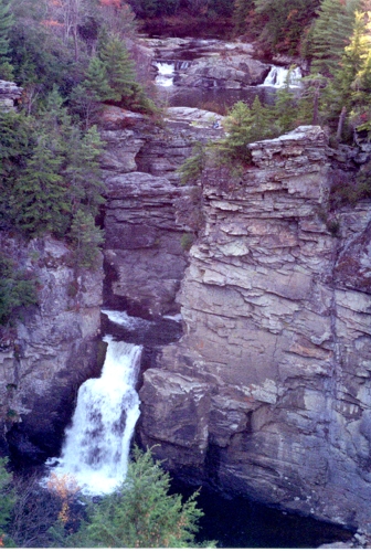 Day 38, (6144) 97 miles to Linville Falls, NC Day 38, (6144) 97 miles to Linville Falls, NC
I woke to see four deer heading through the campground on their way to the comfort station. I guess everybody needs a little comfort in the morning. While walking through the woods out onto a prominent I flushed two more deer. There were islands of good color today but much of it is fading. I stopped at several craft centers and took a hike to see Linville Falls.
The picture to the right shows upper and lower Linville Falls
Day 39, (6240) 96 miles to Mt. Pisgah Campground, NC
The promised rain held off all day and the colors improved every mile I traveled to the south except for the higher elevations. This afternoon was definitely in the Zone with the best fall foliage I have seen since Canada. Unfortunately that's when the clouds came too. I stopped at the Folk Art Center with some traditional but mostly contemporary crafts of the Appalachian Region. Maren would have loved it; I know
I did.
Mt. Pisgah Campground in NC on the Blue Ridge Parkway November 1, 1997
I had a bad scare this morning. I popped the pills I take every day into my mouth and gulped them down. They lodged in my throat cutting off my air path. There I was standing around in my underwear trying to perform the Heimlich maneuver on myself. It can't be done; there is not enough leverage. I tried to cough, but you can't exhale if you can't inhale. It's a really strange feeling. The body keeps trying to breathe but nothing works. It wasn't anything like holding your breath or fighting for air after a deep dive when
skin-diving. I wasn't fighting for breath. I just couldn't breathe. I can't explain the difference succinctly, but believe me, there is a difference.
I remember telling myself not to panic while thinking how stupid it would be if I died taking my pills! Maren would blame herself for not being here, and my brother Don would tell everybody "I told him he shouldn't go by himself." I remembered seeing a tracheotomy done on some TV show using the barrel end of a ballpoint pen to create an airway. Great, I thought, if it didn't work some idiot would find my body and say that I committed suicide by slitting my throat. I tried to find something hollow to jam down my throat without luck so I jammed my finger down. At that point I saw the butane lighter use to light the gas burner on the stove. It's working end is a six-inch long tube about three-eighth of an inch in diameter. Thankfully I didn't need it; the finger worked after several tries. Fifteen minutes later I was ok.
I have no idea how long these thoughts ran through my mind or how much time passed before I dislodged the pills. It all happened at the same time, trying to figure a way out of my situation with all those extraneous thoughts running around in my head. Luckily I didn't panic, but I do remember being really upset with myself for getting into this situation. I now take my pills one at a time with plenty of water to wash each one down.
Day 40, (6314) 74 miles to Cherokee, NC at the end of the Blue Ridge Parkway
Fall on the Blue Ridge Parkway
It rained hard last night but the morning was bright and sunny. The colors were grand in all
but the highest elevations but it soon clouded over. I ventured in and out of fog banks for the last 50 miles of the parkway. There
are lots of tunnels in this last section and, let me tell you, it's really weird to drive into a pitch black tunnel full of
fog. Most of the time the fog stayed outside, but every now and again it drifted through the tunnel and when it did all
you can see are your headlights glinting of the reflective strips installed along the sides. You can't see anything else,
no top, no bottom, just those wonderful side markers.
At the end of the Blue Ridge Parkway lies the Great Smoky Mountains and the national park of the same name. I arrived at the visitor's center around 1:00 just as it started to rain. The park was open but everything was socked in so I decided to visit the town of Cherokee instead and then spend the night at the local KOA.
Cherokee is not your typical Indian Reservation. There are the inevitable casino and all manner of shops, stores, restaurants, and amusement centers. I didn't stay long but if Maren was with me I am sure we would have stayed for two days.
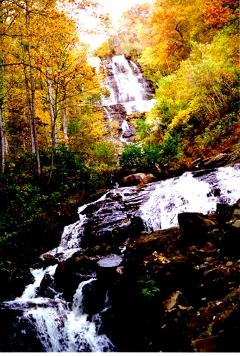
Day 41, (6453) 139 miles to Amicalola Falls State Park at the foot of Springer Mountain
It rained hard last night but the morning was bright, clear and cold. I followed several rain-swollen streams through the foothills of the Great Smoky Mountains heading for the southern end of the Appalachian Trail. There were many river rafting outfits along the way and several stream-side turnoffs had cars with kayak racks on top but I didn't see any kayaks in the water.
 The leaves were still colorful but dropping fast. As the wind picked up I wrestled the
motor home from North Carolina, through the southeastern corner of Tennessee, and south into Georgia. The leaves were still colorful but dropping fast. As the wind picked up I wrestled the
motor home from North Carolina, through the southeastern corner of Tennessee, and south into Georgia.
The Amicalola Falls -- on the right -- is a series of seven falls dropping 729 feet. Its name comes from the Cherokee meaning "tumbling waters." The trail to its base is fairly strenuous but well worth the effort, especially with all the rain last night. The trail to the top of Spencer Mountain and the southern end of the Appalachian Trail, on the other hand, is 8.5 miles one way to the top. I passed.
Day 42, (6540) 87 miles to Stone Mountain, Georgia just east of Atlanta
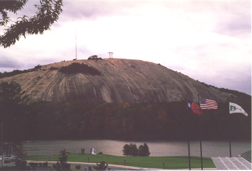
A breezy wedding at Stone Mountain
Stone Mountain is a giant 825 foot high domed shaped granite rock sitting on a roiling plain. Its base extends under half of Georgia and part of North Carolina. On the north side of the rock is a Confederate Memorial Carving of Jefferson Davis, Robert E. Lee and Stonewall Jackson. It's the largest relief carving in the world measuring 90 by 190 feet and extends 12 feet into the mountain.
It can be seen in the picture above to the left and above of the Confederate
flag.
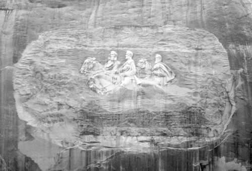
Confederate Memorial Carving on the side of Stone Mountain
The mountain really is a single rock with no large cracks, ridges or flaws. Of course there are pieces that are flaking off and some have formed shallow pits that support small islands of some very unique vegetation. There are also small six to eight inch round pits about an inch deep that look a lot like shell holes which I believe are caused by lighting strikes. All and all it's a very surreal place.
Day 43, (6830) 290 miles to Stephen Foster State Folk Culture Center near White Springs, FL
The trip down from Atlanta saw the end of the fall foliage for now. Atlanta is still near prime; however, as one moves south it slowly fades to green. And for the first time in weeks insects have been splashing my windshield.
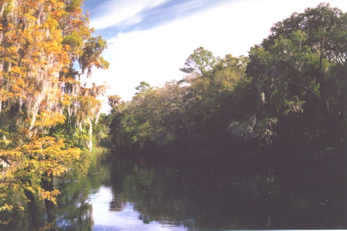
The moss draped Suwannee River
Tonight I am camped next to the Suwannee River under moss draped trees. Tomorrow starts the Rural Folklife Days here in the state park. Besides the Stephen Foster Museum there will be demonstrations on blacksmithing, cow whip construction, quilting, and a craft shop to name a few. I may even learn how to sing Suwannee, but, alas, who can top Al Jolson in The Jazz Singer.
Day 44, (6961) 131 miles to Holiday Travel Resort in Leesburg, Florida
This morning a thousand or so kids from many schools showed up at the park for the demonstrations. I saw the ones on blacksmithing and cow whip construction -- known outside of Florida as a bull whip. Sneaking in between groups of kids I had some interesting conversations with the demonstrators who are all retired folks interested in passing on a life's knowledge.
The resort I am staying at is great. The enclosed spa and heated pool were greatly appreciated by my chilled and battered body. Tomorrow I will try the heated outdoor pool but I won't have time for tennis, golf or a dozen other distractions as there is too much work to do. You know the old adage, when the wife's away the husband must work his butt off cleaning up before she returns.
Day 45, (7126) 165 miles to Valrico, Florida just east of Tampa on Route 4.
Orlando International Airport is wonderful. The entrance is off the Florida Turnpike so you have to pay a toll a few hundred feet before entering the airport. Then if you happen to be driving a vehicle over 7 feet high they send you back 4 miles to park in their Park-and-Ride lot right off the Turnpike. If they had posted signs earlier I could have saved myself an 8 mile drive and a seventy-five cent toll. Well, I guess that's why they don't, have to get that toll.
Maren's flight was 15 minutes late, but the shuttle bus was at its stop when we arrived for the ride back to the
motor home. The trip to my brother Don's home is straight down route 4 and ends with a series of twists and turn on back roads without any street lights. Well I got turned around and Maren explained to me just how stupid is was to get lost when I have all those maps and directions. She's right of course, but it was hard to see the wisdom of her words at the time.
I pulled out my computer with its Street Atlas and found out where we were. Made a guess, turned left and went to the next major intersection. Maren took this opportunity to refine her evaluation of my navigational ability and got out of the
motor home to call Don while I tried to find out where we were on the map. Well the phone ate her only quarter and she came storming back inside.
"No sweat," I said, "I was going the wrong way. All I have to do is backtrack about a mile and turn left."
Well that did it. She lit into me like a Bear just out of hibernation. There are times when it's best to just shut up and take it but I never seem to realize it in time. We arrived about 10 minutes later as Maren finished her critique of my life in general and my driving ability in particular.
P.S. After 18 hours of flying around and several more hours driving, it's no wonder Maren was a little short on patience. One thing is for certain, it's sure nice having her back.
Go to Part 3: Heading West
|
|
Let me know if you Like this article & please
leave a comment.
|
|
|
|
Please rate Tom and Maren's Fall Fantasy
Part 2
and let me know what you think. Just click on one of the ratings below.
[ * Stinks
| ** So-So
| *** Good
| **** Great
| ***** Loved It ]
Your feedback is important to me. Any additional comments will be appreciated. Thanks, Tom Heald.
|

Free counter provided by Vendio on March 26, 2009.
|